Singapore Whole sky Nighttime Image SEGmentation Database
- Citation Author(s):
-
Soumyabrata Dev ( Nanyang Technological University (NTU), Singapore)Florian Savoy (Advanced Digital Sciences Center (ADSC), University of Illinois at Urbana-Champaign, Singapore)Yee Hui Lee ( Nanyang Technological University (NTU), Singapore)Stefan Winkler (Advanced Digital Sciences Center (ADSC), University of Illinois at Urbana-Champaign, Singapore)
- Submitted by:
- Soumyabrata Dev
- Last updated:
- DOI:
- 10.21227/jsf0-ga67
- Research Article Link:
- Links:
 944 views
- Categories:
- Keywords:
Abstract
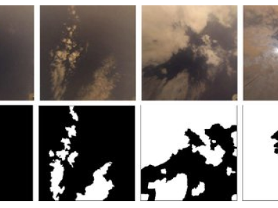
The SWINSEG dataset contains 115 nighttime images of sky/cloud patches along with their corresponding binary ground truth maps The ground truth annotation was done in consultation with experts from Singapore Meteorological Services. All images were captured in Singapore using WAHRSIS, a calibrated ground-based whole sky imager, over a period of 12 months from January to December 2016. All image patches are 500x500 pixels in size, and were selected considering several factors such as time of the image capture, cloud coverage, and seasonal variations.
S. Dev, F. M. Savoy, Y. H. Lee, S. Winkler.
Nighttime sky/cloud image segmentation.
Proc. IEEE International Conference on Image Processing (ICIP), Beijing, China, Sep. 17-20, 2017.
Please cite the above paper if you use the SWINSEG dataset.
Instructions:
The detailed instructions in using this dataset can be found in the readme.pdf file of the zipped dataset file.