L-AVATeD: the LiDAR And Visual wAlking Terrain Dataset

- Citation Author(s):
- Submitted by:
- David Whipps
- Last updated:
- DOI:
- 10.21227/g0xz-m347
- Data Format:
 330 views
- Categories:
- Keywords:
Abstract
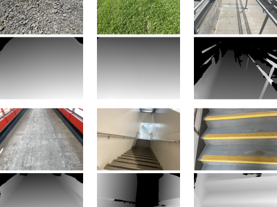
An understanding of local walking context plays an important role in the analysis of gait in humans and in the high level control systems of robotic prostheses. Laboratory analysis on its own can constrain the ability of researchers to properly assess clinical gait in patients and robotic prostheses to function well in many contexts, therefore study in diverse walking environments is warranted. A ground-truth understanding of the walking terrain is traditionally identified from simple visual data. Deep Neural Networks, and in particular Convolutional Neural Networks are ideal for this classification task, but require extensive training data. Even moderately priced modern mobile devices include a suite of sensors capable of gathering not only visual images of walking terrain, but also depth data using built-in LiDAR sensors, and classifiers incorporating this multimodal data can outperform simple visual classification. The purpose of this dataset is to provide researchers and engineers a baseline set of multi-class, multi-sensor, walking terrain data, but its utility could be extended to any number of uses, including autonomous robots. We therefore present L-AVATeD: the Lidar And Visible wAlking Terrain Dataset, consisting of ~8,000 pairs of visual (RGB) and Depth (LiDAR) data. The data are divided into 9 classes of walking terrain typical of the built environments inside and surrounding North American academic and healthcare institutions.
Instructions:
A preprocessed, resized and pre-split version of the database (suitable for e.g. training deep neural networks) is available in the file "lavated_split.zip." This version of the dataset is split into training, validation and test sets with an approximate ratio of 80%, 10%, 10%.
The raw dataset including: full-sized RGB images in HEIC format, full-sized LiDAR depth data stored as 32-bit disparity maps in TIFF format, as well as device orientation vectors are available by downloading the file "lavated_raw.zip".
Scripts for preprocessing and partitioning the full-sized dataset can be found in "lavated_scripts.zip".
More details related to the class names, file-naming scheme and data formats can be found in the documentation file "README.md".


