Landmine Thermal Image Series
- Citation Author(s):
-
Ugur Murat Leloglu
 (Middle East Technical University, Turkey)
Serkan Kaya (Ataturk University, Turkey)
(Middle East Technical University, Turkey)
Serkan Kaya (Ataturk University, Turkey) - Submitted by:
- Ugur Leloglu
- Last updated:
- DOI:
- 10.21227/tg8m-6f29
- Data Format:
- Links:
 3855 views
- Categories:
- Keywords:
Abstract
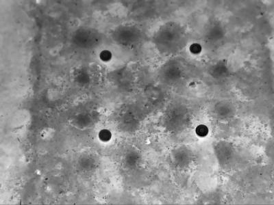
Infrared imaging from aerial platforms can be used to detect landmines and minefields remotely and can save many lives. This dataset contains thermal images of buried and surface landmines. The images were recorded from a fixed camera for 24 hours with 15-minute intervals. DM-11 type anti-personnel landmines were used. This dataset is available for landmine detection research.
Instructions:
Instructions are given in the attached pdf file.
Hyunjae Jo
Fri, 01/15/2021 - 06:50
Permalink
This dataset is perfect
cagri suicmez
Thu, 03/11/2021 - 17:40
Permalink
Dataset Files
LOGIN TO ACCESS DATASET FILES
Open Access dataset files are accessible to all logged in users. Don't have a login? Create a
free IEEE account. IEEE Membership is not required.