Datasets
Open Access
Mobile Communication System Measurements and Satellite Images
- Citation Author(s):
- Submitted by:
- Jakob Thrane
- Last updated:
- Tue, 05/17/2022 - 22:21
- DOI:
- 10.21227/1xf4-eg98
- Data Format:
- Link to Paper:
- Links:
- License:
- Creative Commons Attribution
 4530 Views
- Categories:
- Keywords:
Abstract
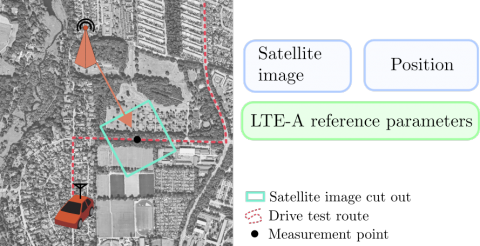
Drive testing is a common practice by mobile operators to evaluate the performance and coverage of their deployed mobile communication systems. Drive testing is, however, a very expensive practice. Furthermore, due to the complexity of future 5G mobile networks, accurate and efficient ways of optimizing and evaluating coverage are needed. The dataset contains measurements from a deployed LTE-A mobile communication system and corresponding satellite images. The dataset has been generated to explore the idea of utilizing information from satellite images to predict (and improve predictions) of signal strength parameters in unseen locations.
The feature matrix
feature_matrix.csv
Contains the following features:
- Longitude
- Latitude
- Speed (in km/h)
- Distance (in km)
- Distance_x
- Distance_y
- PCI (Integer)
- PCI_64 (811 MHz base station) (one-hot encoding)
- PCI_65 (811 MHz base station) (one-hot encoding)
- PCI_302 (2630 MHz base station) (one-hot encoding)
The output matrix
output_matrix.csv
- SINR (dB)
- RSRP (dBm)
- RSRQ (dB)
- Power/RSSI (dBm)
Each row corresponds to an image in mapbox_api/*.png
More from this Author
Dataset Files
Measurements output_matrix.csv (1.84 MB)
Position and transmitting base station feature_matrix.csv (5.86 MB)
Images of resolution 256x256x3 mapbox_api.zip (1,008.96 MB)
Open Access dataset files are accessible to all logged in users. Don't have a login? Create a free IEEE account. IEEE Membership is not required.


