WalnutData: A UAV Remote Sensing Dataset of Green Walnuts and Model Evaluation
- Citation Author(s):
-
Mingjie Wu
 (Yunnan Normal University)
Chenggui YangHuihua WangChen XueYibo WangHaoyu WangYansong WangCan PengYuqi HanRuoyu LiLijun YunZaiqing ChenYuelong Xia
(Yunnan Normal University)
Chenggui YangHuihua WangChen XueYibo WangHaoyu WangYansong WangCan PengYuqi HanRuoyu LiLijun YunZaiqing ChenYuelong Xia - Submitted by:
- Mingjie Wu
- Last updated:
- DOI:
- 10.21227/f8hc-6r19
- Links:
 246 views
- Categories:
- Keywords:
Abstract
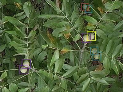
With the gradual maturity of UAV technology, it can provide extremely powerful support for smart agriculture and precise monitoring. Currently, there is no dataset related to green walnuts in the field of agricultural computer vision. Therefore, in order to promote the algorithm design in the field of agricultural computer vision, we used UAV to collect remote sensing data from 8 walnut sample plots. Considering that green walnuts have the characteristics of being affected by various lighting conditions and being occluded, we constructed a large-scale dataset with a higher fine-grained target feature - WalnutData. This dataset contains a total of 30,240 images and 7,062,080 instances, and there are 4 target categories: illuminated from the front and not occluded (A1), backlit and not occluded (A2), illuminated from the front and occluded (B1), and backlit and occluded (B2). Then, we evaluated many mainstream algorithms on WalnutData and used these evaluation results as the baseline standard.
Instructions:
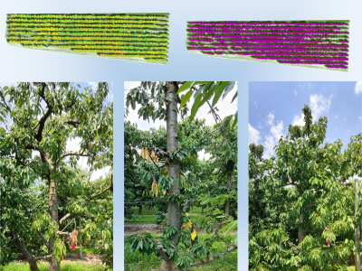
We conducted data collection on 8 walnut sample plots between July 18 and September 14, 2024. All these sample plots are located in Yangbi County, Dali Bai Autonomous Prefecture, Yunnan Province, China. In addition, in order to capture the changes in lighting conditions, we carried out the shooting between 9:00 and 19:00. The data collection equipment used uniformly was a DJI Matrice 300 RTK unmanned aerial vehicle (UAV) and a Zenmuse P1 (35mm F2.8) lens. The UAV took photos from a top-down angle (-90°) throughout the process according to the pre-planned flight route, and the flight path completely covered the scope of each sample plot. To reduce the impact of too high a flight altitude and too fast camera movement on the imaging quality, we set the flight speed between 1-3m/s and the flight altitude between 12-30m while ensuring flight safety.
Since the resolution of the UAV aerial images (8192×5460 pixels) is too large, which is not conducive to the training of the model, in this study, the screened original images were all cut with a step size of 512. The resolution of the cut images is 1024×1024 pixels. After the processing of the above steps, the dataset of this study was finally formed, which consists of a total of 30,240 images.


The dataset and all evaluation results can be obtained at https://github.com/1wuming/WalnutData.