RMPS (Rupnagar Maize Paddy Sugarcane) dataset

- Citation Author(s):
-
Karan Singh (Indian Institute of Technology Ropar)Rajiv Ranjan (Plaksha University)Sushil Ghildiyal (Indian Institute of Technology Ropar)Shashank Tamaskar (Plaksha University)Neeraj Goel (Indian Institute of Technology Ropar)
- Submitted by:
- Sushil Ghildiyal
- Last updated:
- DOI:
- 10.21227/rfed-3z84
 203 views
- Categories:
- Keywords:
Abstract
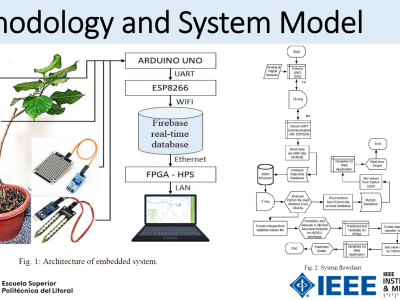
The study focused on two regions in Rupnagar district, India, with an area of 216 km² as shown in Fig. 1a, using satellite data from June to November 2023. The upper region predominantly features paddy and maize, while the lower region includes paddy and sugarcane. Satellite images were obtained from PlanetScope’s 130-satellite constellation, with a spatial resolution of 3 meter. A total of 32 images, captured between late May and mid-November 2023, were used, all with less than 15% cloud cover.
Instructions:
The dataset folder is RMPS dataset, this folder contains three subdirectories namely:
1. upperArea
2. lowerArea
3. Groundtruth