Piedmont Photovoltaic Panels Dataset

- Citation Author(s):
-
Compagnia Generale Riprese aeree s.p.a. (CGR s.p.a.)Paolo Pasquali (LINKS Foundation)Giacomo Blanco (LINKS Foundation)
- Submitted by:
- Edoardo Arnaudo
- Last updated:
- DOI:
- 10.21227/f0nc-hc38
- Data Format:
- Links:
 979 views
- Categories:
- Keywords:
Abstract
Solar energy production has grown significantly in recent years in the European Union (EU), accounting for 12\% of the total in 2022. The growth can be attributed to the increasing adoption of solar photovoltaic (PV) panels, which have become cost-effective and efficient means of energy production, supported by government policies and incentives. The maturity of solar technologies has also led to a decrease in the cost of solar energy, making it more competitive with other energy sources.
As a result, there is a growing need for efficient methods for detecting and mapping the locations of PV panels. An automated detection can in fact save time and resources compared to manual inspection. Moreover, the resulting information can also be used by governments, environmental agencies and other companies to track the adoption of renewable sources or to optimize the energy distribution across the grid.
However, building such an automated system presents several challenges, including the availability of high-resolution aerial imagery, high-quality, manually-verified labels and annotations, and consequently effective models.
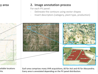
We address these challenges by constructing a dataset of PV panels using very-high resolution (VHR) aerial imagery, specifically focusing on the region of Piedmont in Italy. The dataset comprises 105 large-scale images, providing more than 9,000 accurate and detailed manual annotations, including a set of attributes such as the PV panel category.
On this dataset, we perform a comprehensive benchmark evaluation of different deep learning techniques, comparing semantic and instance segmentation approaches and making ad-hoc modifications to address specific the issues of this task, such as the wide range of scales of the installations and the sparsity of the annotations.
Instructions:
Instructions to access the Piedmont dataset for PV panel delineation.
Last update: 01-02-2023
Dataset Access and Specifications
You can download the dataset from:
- IEEE Dataport: https://ieee-dataport.org/documents/piedmont-photovoltaic-panels-dataset
- Zenodo: TBA
Structure
The dataset is organized in directories, including annotations, areas and ortho, divided into three separate folders. Once every zip is downloaded, its internal structure is as follows:
annotations/
├─ pv_panels.shp
├─ ...
areas/
├─ piedmont_areas.shp
├─ ...
ortho/
├─ n45e008t245_32_30.tif
├─ n45e008t245_32_30.tfw
├─ ...
The content of each folder can be summarized as follows:
annotationscontains a single shapefile, which in turns provides every annotation available in the dataset.areasalso contains a simple shapefile, describing the surface covered by each single image.orthocontains 105 pairs ofTIFF+TFWfiles, providing the 4-band RGBIR georeferenced images.
Shapefile attributes
Each shapefile contains additional attributes. In particular, the PV panels shapefile contains the following information:
- ID: identifier of the single panel
- plant ID: identifier for the group
- region: Region of the panel, always "Piemonte" in this case
- province: which province the panel belongs to
- plant_type: either "mono cristallino" or "poli cristallino"
- orientation: how is the panel oriented
- power: estimated power generation in W
- surface: how large is the delineation in m2
- notes: possible additional indications
- geometry: the actual polygon


