Crop survey ----ground truth for crop mapping and monitoring
- Citation Author(s):
-
Heather McNairn (Agriculture and Agri-Food Canada)Xianfeng Jiao (Agriculture and Agri-Food Canada)
- Submitted by:
- Xianfeng Jiao
- Last updated:
- DOI:
- 10.21227/x38x-3h75
- Data Format:
 365 views
- Categories:
- Keywords:
Abstract
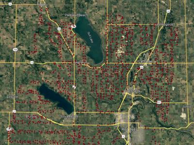
The dataset provides crop-type surveys for Canada's prairie provinces (Manitoba, Saskatchewan and Alberta) in 2020 and 2021. The data were collected via windshield survey(driving through the countryside with GPS-enabled data collection software and satellite imagery). Crop-type points and their geographic coordinates on the ground were gathered using data collection software. Field boundaries were identified on satellite imagery. A single observation point is dropped in a homogeneous area within the field.
The crop type survey was collected during the growing season. The crop types are valid only for the specific year of collection, as changes to the crop type grown occur from year to year in Canada.
These survey point sources can be used as training or reference sites for crop monitoring and mapping with satellite observations.
Instructions:
Open the KMZ file with Google Earth Pro and click the point to see the crop type and survey date.


crop survey
very good