Datasets
Standard Dataset
3D Visualisation of New Hybrid-Rotational Ground Penetrating Radar For Subsurface Inspection of Transport Infrastructure - Data
- Citation Author(s):
- Submitted by:
- Thomas McDonald
- Last updated:
- Fri, 02/07/2025 - 05:38
- DOI:
- 10.21227/sdfd-f285
- Data Format:
- Research Article Link:
- License:
 536 Views
- Categories:
- Keywords:
Abstract
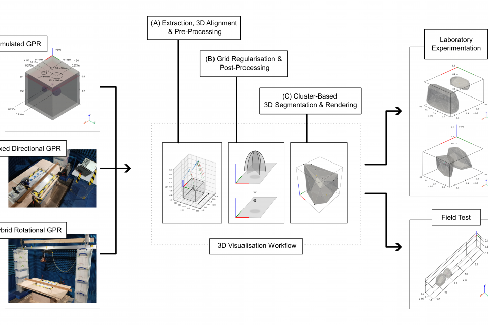
Ground Penetrating Radar (GPR) facilitates the detection and localisation of subsurface structural anomalies in critical transport infrastructure (e.g. tunnels), better informing targeted maintenance strategies. However, conventional fixed-directional systems suffer from limited coverage - especially of less-accessible structural aspects (e.g. crowns) - alongside unclear visual output of anomaly spatial profiles, both for physical and simulated datasets. To tackle these limitations, new hybrid-rotational GPR utilises novel 360-degree orientable air-launched antennas to increase subsurface coverage, principally in tunnels. Prototype systems currently lack a versatile workflow to generate practical visual output for surveyors. This study develops a versatile visualisation workflow based on entirely open access tools, returning 3D spatial profiles of subsurface anomalies in (i) simulated, (ii) fixed-directional and (iii) hybrid-rotational GPR datasets. Work includes development of two unique hybrid-rotational GPR systems, for laboratory and in-field data collection respectively. Following initial 3D grid alignment and smoothing, data undergoes 3D Stolt migration, normalisation and proximal clustering via Hierarchical Density-Based Spatial Clustering of Applications with Noise (HDBSCAN). This returns segmented point subsets associated with suspected structural anomalies. Finally, 3D convex hulls are recovered using the QuickHull method. Detection and localisation performance is first appraised through numerical simulation in open-source software gprMax. Practical laboratory experimentation follows, with both commercial fixed-directional system and developed hybrid-rotational GPR, before in-field demonstration on a large-scale, tunnel subsurface analogue. Resulting 3D visualisations successfully identify the presence of all targets, consistently localising anomalies to within decimetre length scales, evidencing the potential practical insight this technology could provide future infrastructure managers.
Order of subdirectories correspond to relevant order of tests conducted in the associated manuscript.
Datasets can be viewed directly with an appropriate viewer application (e.g. NotePad++, Paraview, VS Code, HDF5 Viewer, etc) subject to file type.
Subdirectories can be passed in current state to python-based 3D visualisation workflow associated with the manuscript.
For related codes, see https://github.com/TMc-DevTools/3D_Visualisation_Hybrid-Rotational_GPR.git
For further information, please contact the corresponding author.
Thomas McDonald
Newcastle University (UK)
email: thomas.mcdonald@newcastle.ac.uk


