Landsat data of surface reflectance of different landforms on the Qinghai-Tibet Plateau from 1990 to 2024
- Citation Author(s):
-
Shaofan Tang
 (Yunnan agriculture university)
- Submitted by:
- Shaofan Tang
- Last updated:
- DOI:
- 10.21227/ej41-7r41
- Data Format:
 250 views
- Categories:
- Keywords:
Abstract
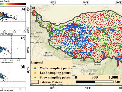
Known as the “Water Tower of Asia,” the Tibetan Plateau plays an important role not only in regional hydrology, but also in the larger, more global water cycle, as well as climate regulation. While this region plays such an important role, things get difficult when it comes to extracting water data using remote sensing techniques—primarily because of snow interference, which leads to all kinds of misjudgments and detection errors. This makes long-term monitoring of water resources a real challenge, especially in those high-altitude, high-latitude regions that are prone to snow accumulation. So, taking all these complications into account, we came up with this new method—the Snow-Water Separation Detection Method (SWS)—which relies on a set of decision rules that combine multiple spectral indices, and what it essentially does is help us separate snow from water bodies in satellite imagery more effectively. The results have proven to be very impressive: validation tests showed an overall accuracy of 96.93%, which means that it is basically very effective, especially in those areas where snow tends to interfere with the data. Now, we apply this method to a huge dataset—159,000 Landsat 5, 7, 8, and 9 images from 1990 to 2024—covering the entire Tibetan Plateau. Interestingly, when we analyzed it, we found a fairly strong correlation between changes in the water bodies and changes in temperature and precipitation patterns, which directly indicates how climate change is affecting water resources in the region. All in all, this approach is not only practical, but also scalable. It provides a powerful solution for monitoring large-scale water bodies, and its potential applications go far beyond this study, contributing to fields ranging from hydrological modeling to climate change research, and providing new insights into how we can sustainably manage water resources in these ice-covered, high-altitude regions.
Instructions:
This experiment aims to analyze the characteristics of surface water, snow, and non-water/non-snow areas by collecting approximately 2,000 sample points in the Qinghai-Tibet Plateau region. The sample points will be classified into water points, snow points, and non-water/non-snow points. These points will be used to extract Surface Reflectance (SR) data from Landsat imagery.