SigMF
In this dataset, we conducted a spectrum monitoring experiment in an urban environment. The helikite flies up to an altitude of 400 feet throughout the day from noon to 9 p.m. during NC State’s Packapalooza festival in August, 2022. The spectrum is swept up to 6 GHz. Every sweep takes around 1 minute, while after every 4 measurements, the 5th measurement takes close to 5 minutes due to another data collection activity running in parallel. The photo of a flying Helikite at the experiment site is shown in the dataset image.
- Categories:
 362 Views
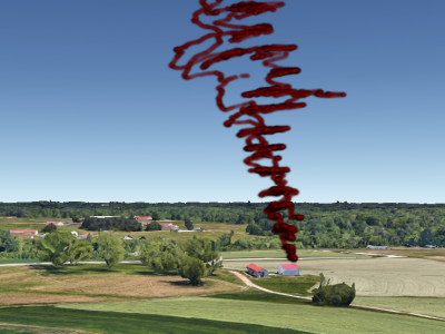
In this dataset, we conduct the spectrum monitoring experiment in AERPAW Lake Wheeler site, which can be classified as a rural area. The helikite flies up to an altitude of 500 feet at increments of 10 meters, while waiting for 5 minutes in between altitude changes. The spectrum is monitored up to 6~GHz. The trajectory of the helikite mapped on top of the experiment site during the flight is in the dataset image. Small random variations in altitude due to wind can also be observed.
- Categories:
 181 Views
Recently, unmanned aerial vehicles (UAVs) have been receiving significant attention due to the wide range of potential application areas. To support UAV use cases with beyond visual line of sight (BVLOS) and autonomous flights, cellular networks can provide connectivity points to UAVs and provide remote control and payload communications. However, there are limited datasets to study the coverage of cellular technologies for UAV flights at different altitudes.
- Categories:
 916 Views
Opening up of the CBRS band for the secondary users' transmissions poses challenges in the protection of incumbent radar users from co-channel interference. The use of Machine Learning algorithms for addressing these challenges requires representative real-world datasets.This dataset contains overlapping radar and LTE signals captures over-the-air in the shared CBRS band using an experimental testbed composed of software defined radios in RF anechoic chamber.
- Categories:
 1305 Views


