A novel fusion Python application of data mining techniques to evaluate airborne magnetic datasets

- Citation Author(s):
-
John Stephen Kayode
(Universiti Teknologi PETRONAS, Persiaran UTP, 32610 Seri Iskandar, Perak Darul Ridzuan, Malaysia)
Yusri Yusup (Environmental Technology Programme, School of Industrial Technology Universiti Sains Malaysia 11800 USM Penang. Malaysia) - Submitted by:
- John Kayode
- Last updated:
- DOI:
- 10.21227/9s34-kc72
- Data Format:
 476 views
- Categories:
- Keywords:
Abstract
Depths to the various subsurface anomalies have been the primary interest in all the applications of magnetic methods of geophysical prospection. Depths to the subsurface geologic features of interest are more valuable and superior to all other properties in any correct subsurface geologic structural interpretations. The varied nature of the subsurface geological terrains in the study area as obtained from the data, were delineated from the enhanced georeferenced airborne magnetic datasets with the primary objective of enhancing the signatures of the subsurface structural and lithologic boundaries associated with joints; major and minor faults, rock contacts and fractures underained the Omu-aran schist belt zone. About 343,982 enhanced georeferenced data points, made up of 100 m interspacing between the data points utilising the 3x3 window size were used to suitably map the region across the land area of about 30,568.7 km2. Six structural index values varied from between 0.5-3.0 were delineated with a maximum depth to the magnetic source rocks bodies at about 1.277 km.
Instructions:
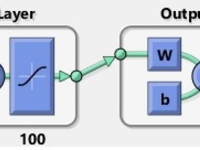
The Neural Network Pattern Recognition help to select the appropriate data sets, create and train the network, and evaluate its performance using the cross-entropy and convolution matrices in MATLAB with fusion python. The Neural Network utilizes a Two-Layer feed-forward network to solve the pattern recognition problem with a six inputs data (i.e., the SI values), a Hidden Layer and a SoftMax Output Layer Neurons. The method excellently classified vector attributes when sufficient neuron in the hidden layer is selected. In this study, a six inputs data from the various SI values obtained was used in one hundred, (100) hidden layers of the neutrons, and weights combined with a six layers output of neutrons, and weights to generate the six-final output that represent each of the SI values depths as shown.
Dataset Files
- PyBase E-W Dpts-0.5SI-Prof-1 (Size: 9.72 KB)
- PyBase E-W Dpts-1.0SI-Prof-1 (Size: 9.76 KB)
- PyBase E-W Dpts-1.5SI-Prof-1 (Size: 9.72 KB)
- PyBase E-W Dpts-2.0SI-Prof-1 (Size: 9.63 KB)
- PyBase E-W Dpts-2.5SI-Prof-1 (Size: 9.57 KB)
- PyBase E-W Dpts-3.0SI-Prof-1 (Size: 9.54 KB)
- PyBase E-W Dpts-0.5SI-Prof-2 (Size: 9.41 KB)
- PyBase E-W Dpts-1.0SI-Prof-2 (Size: 9.44 KB)
- PyBase E-W Dpts-1.5SI-Prof-2 (Size: 9.42 KB)
- PyBase E-W Dpts-2.0SI-Prof-2 (Size: 9.39 KB)
- PyBase E-W Dpts-2.5SI-Prof-2 (Size: 9.29 KB)
- PyBase E-W Dpts-3.0SI-Prof-2 (Size: 9.65 KB)
- PyBase E-W Dpts-0.5SI-Prof-3 (Size: 9.87 KB)
- PyBase E-W Dpts-1.0SI-Prof-3 (Size: 9.85 KB)
- PyBase E-W Dpts-1.5SI-Prof-3 (Size: 9.71 KB)
- PyBase E-W Dpts-2.0SI-Prof-3 (Size: 9.57 KB)
- PyBase E-W Dpts-2.5SI-Prof-3 (Size: 9.51 KB)
- PyBase E-W Dpts-3.0SI-Prof-3 (Size: 9.49 KB)
- PyBase E-W Dpts-0.5SI-Prof-4 (Size: 9.95 KB)
- PyBase E-W Dpts-1.0SI-Prof-4 (Size: 9.94 KB)
- PyBase E-W Dpts-1.5SI-Prof-4 (Size: 9.95 KB)
- PyBase E-W Dpts-2.0SI-Prof-4 (Size: 9.9 KB)
- PyBase E-W Dpts-2.5SI-Prof-4 (Size: 9.87 KB)
- PyBase E-W Dpts-3.0SI-Prof-4 (Size: 9.8 KB)
- PyBase E-W Dpts-0.5SI-Prof-5 (Size: 9.69 KB)
- PyBase E-W Dpts-1.0SI-Prof-5 (Size: 9.46 KB)
- PyBase E-W Dpts-1.5SI-Prof-5 (Size: 9.36 KB)
- PyBase E-W Dpts-2.0SI-Prof-5 (Size: 9.18 KB)
- PyBase E-W Dpts-2.5SI-Prof-5 (Size: 9.13 KB)
- PyBase E-W Dpts-3.0SI-Prof-5 (Size: 9.05 KB)
- PyBase E-W Dpts-0.5SI-Prof-6 (Size: 9.58 KB)
- PyBase E-W Dpts-1.0SI-Prof-6 (Size: 9.35 KB)
- PyBase E-W Dpts-1.5SI-Prof-6 (Size: 9.43 KB)
- PyBase E-W Dpts-2.0SI-Prof-6 (Size: 8.82 KB)
- PyBase E-W Dpts-2.5SI-Prof-6 (Size: 8.78 KB)
- PyBase E-W Dpts-3.0SI-Prof-6 (Size: 9.07 KB)
- PyBase N-S Dpts-0.5SI-Prof-1 (Size: 8.94 KB)
- PyBase N-S Dpts-1.0SI-Prof-1 (Size: 9.94 KB)
- PyBase N-S Dpts-1.5SI-Prof-1 (Size: 9.99 KB)
- PyBase N-S Dpts-2.0SI-Prof-1 (Size: 9.96 KB)
- PyBase N-S Dpts-2.5SI-Prof-1 (Size: 9.97 KB)
- PyBase N-S Dpts-3.0SI-Prof-1 (Size: 9.86 KB)
- PyBase N-S Dpts-0.5SI-Prof-2 (Size: 8.73 KB)
- PyBase N-S Dpts-1.0SI-Prof-2 (Size: 5.63 KB)
- PyBase N-S Dpts-1.5SI-Prof-2 (Size: 8.12 KB)
- PyBase N-S Dpts-2.0SI-Prof-2 (Size: 8.12 KB)
- PyBase N-S Dpts-2.5SI-Prof-2 (Size: 8.12 KB)
- PyBase N-S Dpts-3.0SI-Prof-2 (Size: 8.08 KB)
- PyBase N-S Dpts-0.5SI-Prof-3 (Size: 8.07 KB)
- PyBase N-S Dpts-1.0SI-Prof-3 (Size: 8.22 KB)
- PyBase N-S Dpts-1.5SI-Prof-3 (Size: 8.28 KB)
- PyBase N-S Dpts-2.0SI-Prof-3 (Size: 8.25 KB)
- PyBase N-S Dpts-2.5SI-Prof-3 (Size: 8.26 KB)
- PyBase N-S Dpts-3.0SI-Prof-3 (Size: 8.24 KB)
- PyBase N-S Dpts-0.5SI-Prof-4 (Size: 7.72 KB)
- PyBase N-S Dpts-1.0SI-Prof-4 (Size: 7.86 KB)
- PyBase N-S Dpts-1.5SI-Prof-4 (Size: 7.91 KB)
- PyBase N-S Dpts-2.0SI-Prof-4 (Size: 7.88 KB)
- PyBase N-S Dpts-2.5SI-Prof-4 (Size: 7.84 KB)
- PyBase N-S Dpts-3.0SI-Prof-4 (Size: 7.77 KB)
- PyBase N-S Dpts-0.5SI-Prof-5 (Size: 8.88 KB)
- PyBase N-S Dpts-1.0SI-Prof-5 (Size: 9.07 KB)
- PyBase N-S Dpts-1.5SI-Prof-5 (Size: 9.18 KB)
- PyBase N-S Dpts-2.0SI-Prof-5 (Size: 9.21 KB)
- PyBase N-S Dpts-2.5SI-Prof-5 (Size: 9.19 KB)
- PyBase N-S Dpts-3.0SI-Prof-5 (Size: 9.19 KB)
- PyBase N-S Dpts-0.5SI-Prof-6 (Size: 9.6 KB)
- PyBase N-S Dpts-1.0SI-Prof-6 (Size: 9.83 KB)
- PyBase N-S Dpts-1.5SI-Prof-6 (Size: 9.9 KB)
- PyBase N-S Dpts-2.0SI-Prof-6 (Size: 9.91 KB)
- PyBase N-S Dpts-2.5SI-Prof-6 (Size: 9.86 KB)
- PyBase N-S Dpts-3.0SI-Prof-6 (Size: 9.84 KB)


