Can Artificial Intelligence Untangle Distorted and Compressed Geometries Associated with SAR Images of 3D Objects ?
- Citation Author(s):
-
Abdourrahmane ATTO (Université Savoie Mont Blanc)
- Submitted by:
- Abdourrahmane Atto
- Last updated:
- DOI:
- 10.21227/y3pm-1113
- Data Format:
- Links:
 244 views
- Categories:
- Keywords:
Abstract
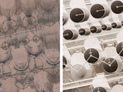
Remote imaging systems raise unprecedented challenges in artificial intelligence. The dataset provided (extracted from the SpaceNet 6 challenge) shows SAR images having distorted intensities (compared to the expected results, the latter being visible in the RGB and NIR images which are also provided) due to the geophysics of the SAR acquisition system and the geometries of ground objects. Can we teach an Artificial Intelligence to find the right re-projections for automatically correcting such distorted and compressed intensities ?
Instructions:
Details on the acqusition systems and the image properties can be found in reference:
Shermeyer, J., Hogan, D., Brown, J., Etten, A.V., Weir, N., Pacifici, F., Hänsch, R., Bastidas, A., Soenen, S., Bacastow, T.M., & Lewis, R. (2020). SpaceNet 6: Multi-Sensor All Weather Mapping Dataset. 2020 IEEE/CVF Conference on Computer Vision and Pattern Recognition Workshops (CVPRW), 768-777.
Dataset Files
- SAR Images #1 (Size: 75.12 MB)
- RGB & NIR Images #1 (Size: 57.69 MB)
- SAR Images #2 (Size: 74.61 MB)
- RGB & NIR Images #2 (Size: 57.57 MB)
- SAR Images #3 (Size: 74.57 MB)
- RGB & NIR Images #3 (Size: 56.55 MB)
- SAR Images #4 (Size: 75.52 MB)
- RGB & NIR Images #4 (Size: 56.45 MB)
- SAR Images #5 (Size: 68.91 MB)
- RGB & NIR Images #5 (Size: 52.17 MB)
- SAR Images #6 (Size: 62.05 MB)
- RGB & NIR Images #6 (Size: 47.31 MB)