Datasets
Standard Dataset
Asian subcontinent dataset (ASCD)
- Citation Author(s):
-
IndrajitKalita
 Boston University
 - Submitted by:
- Indrajit kalita
- Last updated:
- Mon, 12/02/2024 - 17:09
- DOI:
- 10.21227/xgad-sa62
- Data Format:
- Research Article Link:
- Links:
- License:
 142 Views
- Categories:
- Keywords:
Abstract
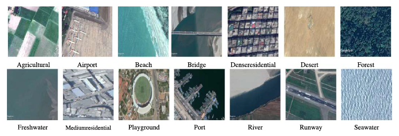
The Asian Subcontinent Dataset (ASCD) is a multisensor dataset that includes geospatial data collected from different countries within the Asian subcontinent, specifically India, Bangladesh, and Sri Lanka. The dataset consists of imagery captured through two main sources: Google Earth Pro software and IKONOS-2 satellite images. ASCD includes 14 distinct land cover classes, ranging from urban areas to natural environments, with 1,674 images. The number of images in each land cover class varies between 100 and 204. Each image in the dataset has a resolution of 227 × 227 pixels and includes three color channels. This dataset provides a valuable resource for research in remote sensing, land cover classification, and environmental monitoring in the Asian subcontinent.
The Asian Subcontinent Dataset (ASCD) is a multisensor dataset collected from different countries in the Asian subcontinent, specifically India, Bangladesh, and Sri Lanka. The dataset consists of remote sensing images from two primary sources: Google Earth Pro and IKONOS-2 satellite images. ASCD contains 14 land cover classes that represent various geographical features and man-made structures. The dataset includes 1674 images with a size of 227 × 227 × 3 (width × height × RGB channels).
This dataset is ideal for training and evaluating machine learning models in areas like land cover classification, environmental monitoring, and remote sensing.
Description of Each Land Cover Class:
- Agricultural: Images representing agricultural fields, crops, and farmlands.
- Desert: Images of dry, arid regions with sparse vegetation.
- Port: Images of seaports or harbor areas.
- Airport: Images of airports, runways, and airstrip areas.
- Forest: Forested areas with a significant presence of trees and vegetation.
- River: Images of rivers, streams, and freshwater bodies.
- Beach: Coastal areas with sandy beaches.
- Freshwater: Ponds, lakes, and other freshwater bodies.
- Runway: Images of runways used for aviation.
- Bridge: Images of bridges or overpasses.
- Medium Residential: Residential areas with a medium population density.
- Seawater: Coastal water bodies such as oceans and seas.
- Denser Residential: Densely populated urban residential areas.
- Playground: Parks, open spaces, and recreational areas.
Each class folder contains a number of images ranging from 100 to 204 images, providing a total of 1674 images.
Image Format:
- Each image is of size 227 × 227 × 3 (width × height × RGB channels).
- Images are stored in common formats like JPEG.
Documentation
| Attachment | Size |
|---|---|
| 3.34 KB |


