Exploratory Spatial Data Analysis
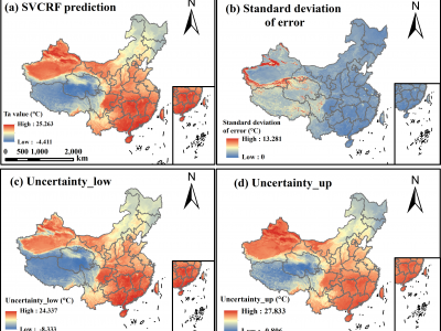
Accurately predicting spatially-continuous daily air temperature (Ta) is critical for agriculture, environmental management, and ecology. While meteorological stations provide precise Ta data, their spatial coverage is limited. Remotely-sensed Land Surface Temperature (LST), often fused with meteorological data, offers broader spatial coverage but struggles due to complex relationships between Ta and LST, influenced by factors like topography and human activities.
- Categories:
 352 Views
Accurately predicting spatially-continuous daily air temperature (Ta) is critical for agriculture, environmental management, and ecology. While meteorological stations provide precise Ta data, their spatial coverage is limited. Remotely-sensed Land Surface Temperature (LST), often fused with meteorological data, offers broader spatial coverage but struggles due to complex relationships between Ta and LST, influenced by factors like topography and human activities.
- Categories:
223 Views