VignaBagnolo
- Citation Author(s):
-
Emanuele Goldoni (OCNO Srl, Italy)Fabio Dell'Acqua (University of Pavia, Italy)
- Submitted by:
- Emanuele Goldoni
- Last updated:
- DOI:
- 10.21227/z148-2d22
- Data Format:
 103 views
- Categories:
- Keywords:
Abstract
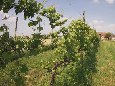
The dataset was captured from a vineyard in Bagnolo San Vito, Italy. The dataset comprises sensor readings and high-resolution images collected from 24 March 2024 to 24 December 2024, using one high-resolution camera and a LoRaWAN network of 2 air sensors and 6 soil sensors. The sensors measured air temperature and humidity, soil dielectric permittivity, and soil temperature every 10 minutes. The camera captured one 4-Mpixel RGB image per day.
Instructions:
The coordinates.csv file contains the GPS coordinates (latitude and longitude) of each device deployed on the field.
The measurements.csv file contains the values collected by the sensors. Each line consists of five fields: nodeid, timestamp, temperature (in °C), relative humidity or dielectric permittivity (as a percentage), LoRaWan operating radio frequency (in Hz), RSSI (in dBm) and received SNR.
The daily photographs are saved in JPEG format and are stored into three zip file: hires (the original images), lowres (rescaled and compressed version of the original photos) and closeup (zoomed and trimmed version of the original images).


I want to use it to perform temporal analytics.
111