UAV-StrawFire
- Citation Author(s):
-
Xikun Hu (National University of Defense Technology)
- Submitted by:
- Xikun Hu
- Last updated:
- DOI:
- 10.21227/88vn-3389
- Data Format:
 275 views
- Categories:
- Keywords:
Abstract
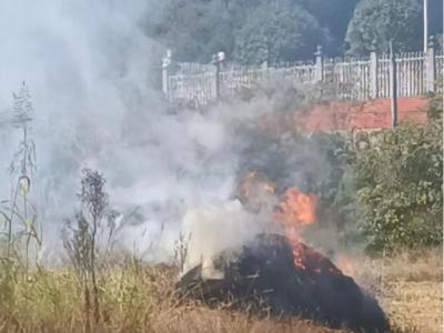
Straw burning poses a significant threat to air quality and public health, primarily due to the emissions of smoke aerosols and associated hazards. Satellite-based remote sensing techniques often have limitations such as long revisit times and low spatial resolution to detect small-scale straw-burning sites. Unmanned aerial vehicles (UAVs) with imaging sensors offer a fast, cost-effective alternative for monitoring and detecting straw fires. By leveraging high-resolution multi-modal images, UAVs can provide valuable insights into the occurrence and spread of straw fires. This paper introduces a straw fire image dataset collected using drones (UAV-StrawFire) during prescribed straw residue burning experiments in southern China. The UAV-StrawFire dataset comprises RGB and thermal infrared (TIR) images and videos of straw fires, along with annotations and labeling that enable researchers to apply detection, segmentation, and tracking algorithms effectively. (1) flame detection in aligned multi-modal frames; (2) flame segmentation to precisely determine fire boundaries, employing real-time lightweight models; (3) flame tracking to monitor the real-time progression of straw fire points.
Instructions:
The main UAV-StrawFire.zip file consists of four folders. The folder "RGB_Img”comprises the RGB images for training and testing, respectively. The folder "TIR_Img" comprises the TIR images for training and testing, respectively. The folder "Flame_Seg_GT" comprises the ground truth for flame segmentation, respectively. The folder "Flame_Det_GT" comprises the ground truth for flame detection, respectively.
The other FLAME_Tracking.zip file comprises five folders which includes the image sequences and corresponding labels for each burning site.


