Multispectral images and In-situ water depth data
- Citation Author(s):
-
Yuquan Wen
- Submitted by:
- Yuquan Wen
- Last updated:
- DOI:
- 10.21227/9096-8c26
 22 views
- Categories:
- Keywords:
Abstract
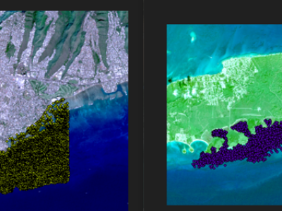
The study area on OH used a Sentinel-2B Level-2A product, acquired on December 1, 2020. At the time of imaging, the solar azimuth angle was 157.43°, and the solar altitude angle was 44.00°. The study area on VQ used a Sentinel-2A Level-2A product, acquired on January 15, 2019. At the time of imaging, the solar azimuth angle was 149.03°, and the solar altitude angle was 44.35°.The in-situ bathymetry data for the OH are high-density airborne LIDAR data, with hundreds of data points per square metre.The In-situ bathymetry data for VQ are low-density shipborne single-beam data, with a few dozen points per square metre.
Instructions:
As the in-situ bathymetry and the remote sensing imagery use different coordinate systems, which would result in biased point locations if used directly, we converted the geographic coordinate system of the in-situ bathymetry data to the WGS-84 coordinate system.