Localization
- Citation Author(s):
-
Changlei Yan
- Submitted by:
- Changlei Yan
- Last updated:
- DOI:
- 10.21227/232k-y026
 216 views
- Categories:
- Keywords:
Abstract
This dataset offers high-quality synchronized data for autonomous driving and multi-sensor fusion research. It's recorded in ROS bag format and includes LiDAR, IMU, and GNSS data. The LiDAR is a Robosense Ruby128 with a 10Hz sampling rate, delivering high-resolution point cloud data. The IMU is an Xsens-680g with a 400Hz sampling rate, providing high-precision acceleration and angular velocity data for vehicle pose estimation and motion compensation. The GNSS is an Xsens-680g integrated module with a 4Hz sampling rate. It uses RTK technology for positioning accuracy within 2cm, offering high-precision global location info. The GNSS data, enhanced by RTK correction, ensures high vehicle position accuracy, ideal for precise path planning and positioning. The LiDAR, IMU, and GNSS data are strictly time-synchronized, facilitating sensor fusion algorithm development and testing. The LiDAR point clouds provide detailed environmental geometry, the IMU captures vehicle dynamics, and the GNSS offers global position references. This dataset is suitable for autonomous driving localization algorithm development, sensor fusion research, environmental perception and mapping, and vehicle dynamics analysis. Researchers can use it for algorithm verification, performance evaluation, and new method exploration.
Instructions:
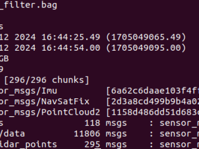
/gnss 118 msgs : sensor_msgs/NavSatFix
/imu/data 11806 msgs : sensor_msgs/Imu
/rslidar_points 295 msgs : sensor_msgs/PointCloud2