Bidirectional Multi-feature Spatiotemporal Fusion Network for Land Surface Temperature with Generative Adversarial Network
- Citation Author(s):
-
Zhang Yong
- Submitted by:
- Yong Zhang
- Last updated:
- DOI:
- 10.21227/j8bj-ez86
 16 views
- Categories:
- Keywords:
Abstract
The European Centre for Medium-Range Weather Forecasts (ECMWF) Reanalysis v.5 (ERA5)-Land and Moderate Resolution Imaging Spectroradiometer (MODIS) land surface temperature.
Instructions:
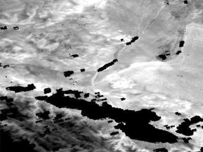
The ERA5 LST were resampled using bilinear interpolation to match the spatial resolution of the MODIS LST. Temporal matching between MODIS LST and ERA5 LST was achieved using the MODIS LST temporal normalization method proposed by Zhang et al\cite{zhang2023multiinformation}. All MODIS LST and resampled ERA5 LST for the HRB in 2013 were partitioned into patches of 128×128 pixels with a 50\% overlap between adjacent patches. MODIS LST patches corresponding to clear-sky conditions were selected to construct the dataset. For the designated test area (as indicated in Figure 1), eight specific datasets, detailed in Table \ref{tab:table1}, were chosen to form the test set. To prevent error propagation during dataset construction, pixels contaminated by clouds were not reconstructed and were consequently excluded from the dataset. During the model inference phase for predicting time-series MODIS LST, the multiinformation fusion network (MIFN) proposed by Zhang et al\cite{zhang2023multiinformation}. was employed to reconstruct cloud-contaminated images. The reconstructed image served as the reference image to avoid uncertainty due to the significant time gap between the reference image and the target moment.


All MODIS LST and resampled ERA5 LST for the Heihe River Basin in 2013.