Learning with Label Proportions on Sentinel-2 RGB imagery

- Citation Author(s):
-
Raul Ramos Pollan (Universidad de Antioquia)Fabio Augusto González Osorio (Unviersidad Nacional de Colombia)
- Submitted by:
- Raul Ramos-Pollan
- Last updated:
- DOI:
- 10.21227/e1kd-w761
- Data Format:
 240 views
- Categories:
- Keywords:
Abstract
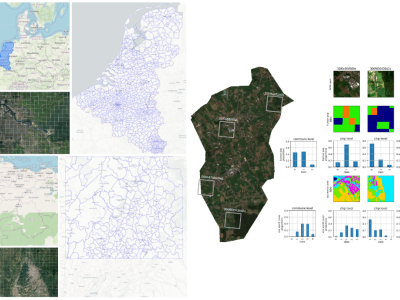
BENELUX Region of Interest (ROI) , comprised of the Belgium, the Netherlands and Luxembourg
We use the communes administrative division which is standardized across Europe by EUROSTAT at:
https://ec.europa.eu/eurostat/web/gisco/geodata/reference-data/administrative-units-statistical-units
This is roughly equivalent to the notion municipalities in most countries.
From the link above, communes definition are taken from COMM_RG_01M_2016_4326.shp and country borders
are taken from NUTS_RG_01M_2021_3035.shp.
COLOMBIA-NE Region of Interest (ROI) is comprised of the east - northeast region of Colombia covering
parts of Santander, Norte de Santander, Boyacá, Bolívar, Antioquia and Cundinamarca.
We use the communes administrative division defined by DANE (Departamento Administrativo
Nacional de Estadística) under "municipios" in the MGN2021 at
https://geoportal.dane.gov.co/geovisores/territorio/mgn-marco-geoestadistico-nacional/
images: Sentinel2 RGB from 2020-01-01 to 2020-31-12
filtered out pixels with clouds during the observation period according to QA60 band following the example
given in GEE dataset info page, and took the median of the resulting pixels
see https://developers.google.com/earth-engine/datasets/catalog/COPERNICUS_S2_SR_HARMONIZED
see also https://github.com/rramosp/geetiles/blob/main/geetiles/defs/sentinel2rgbmedian2020.py
labels: ESA WorldCover 10m V100
labels mapped to the interval [1,11] according to the following map
{ 0:0, 10: 1, 20:2, 30:3, 40:4, 50:5, 60:6, 70:7, 80:8, 90:9, 95:10, 100:11 }
pixel value zero is reserved for invalid data.
see https://developers.google.com/earth-engine/datasets/catalog/ESA_WorldCover_v100
see also https://github.com/rramosp/geetiles/blob/main/geetiles/defs/esaworldcover.py
labels: Global Human Settlement Layers, Population Grid 2015
labels range from 0 to 31, with the following meaning:
label value original value in GEE dataset
0 0
1 1-10
2 11-20
3 21-30
...
31 >=291
see https://developers.google.com/earth-engine/datasets/catalog/JRC_GHSL_P2016_POP_GPW_GLOBE_V1
see also https://github.com/rramosp/geetiles/blob/main/geetiles/defs/humanpop2015.py
Instructions:
See README within zip file
Dataset Files
- Colombia NE with Sentinel 2 RGB input and ESA world cover labels (Size: 1.76 GB)
- Colombia NE with Sentinel 2 RGB input and GHSL human population density labels (Size: 1.73 GB)
- BENELUX with Sentinel 2 RGB input and ESA world cover labels (Size: 1.87 GB)
- BENELUX with Sentinel 2 RGB input and GHSL human population density labels (Size: 1.85 GB)


