WUT-NGSIM: A High-Precision and Trustworthy Vehicle Trajectory Dataset

- Citation Author(s):
-
Yi HeBo CaoChing-Yao Chan
- Submitted by:
- Yi HE
- Last updated:
- DOI:
- 10.21227/hmsb-ka76
- Data Format:
- Links:
 1736 views
- Categories:
- Keywords:
Abstract
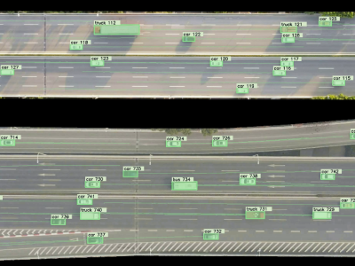
The extraction and construction of high-precision and long-distance vehicle trajectory data and microscopic traffic flow characteristics are critical for traffic safety studies. Current research typically relies on a limited number of datasets which suffer from vehicle detection inaccuracy and limitation of the coverage area. Therefore, we establish a high-precision and long-distance vehicle trajectory dataset of urban scenarios, which is also named as WUT-NGSIM. Primary features of the established dataset: (1) The trajectory data are extracted based on a trajectory extraction framework that contains the video stabilization, vehicle detection and tracking,long-distance trajectory construction, trajectory repair and smoothing, motion feature extraction. (2) The broken trajectory data caused by occlusion are connected through fusing vehicle tracking results at different frame rates based on the Kalman filter and Hungarian Algorithm. (2) Long-distance trajectory data from multi-videos are constructed based on video stitching, video fusion and trajectory fusion. The trajectory precision can be guaranteed by reason of the use of deep learning model and the manual error correction. Finally, the vehicle detection accuracy can reach 100% and the length of the trajectory can reach to 620 meters. This trajectory dataset can provide the high-precision and long-distance vehicle trajectory data for those data-driven studies in transportation.
Instructions:
WUT-NGSIM dataset is established to develop those data-driven studies in traffic safety. And there are currently over 220 minutes of trajectory data extracted from aerial videos uploaded to this website. Each vehicle trajectory dataset consists of four files which are: road image, trajectory visualized video, vehicle trajectory data csv file and txt file. The road image is aerial image captured by drone in a bird’s eye view. The visualized video shows the trajectory of the vehicles in the video. Also, through the visualization video, the trajectory precision can be checked and corrected. The vehicle trajectory data file contains the parameters such as time, position, speed, acceleration and vehicle type, lane ID, DHW, THW, TTC of the vehicles. Finally, if you have any questions or requests regarding the dataset, please contact us at this email: heyi@whut.edu.cn.
Dataset Files
- ExpresswayB_traj_data.zip (Size: 96.24 MB)
- ExpresswayC_traj_data.zip (Size: 25.24 MB)
- ExpresswayD_traj_data.zip (Size: 43.67 MB)
- ExpresswayE_traj_data.zip (Size: 92.58 MB)
- ExpresswayF_traj_data.zip (Size: 89.34 MB)
- ExpresswayH_traj_data.zip (Size: 62.15 MB)
- ExpresswayI_traj_data.zip (Size: 52.19 MB)
- MergeA_traj_data.zip (Size: 93.54 MB)
- MergeB_traj_data.zip (Size: 98.56 MB)
- MergeC_traj_data.zip (Size: 83.8 MB)
- MergeD_traj_data.zip (Size: 71.35 MB)
- MergeE_traj_data.zip (Size: 63.96 MB)
- ExpresswayB_visualization_changed.mp4 (Size: 2.01 GB)
- ExpresswayC_visualization_changed_.mp4 (Size: 500.52 MB)
- ExpresswayD_visualization_changed__.mp4 (Size: 1.5 GB)
- ExpresswayE_visualization_changed_.mp4 (Size: 2 GB)
- ExpresswayF_visualization_changed.mp4 (Size: 2.38 GB)
- ExpresswayH_visualization_changed.mp4 (Size: 1.16 GB)
- ExpresswayI_visualization_changed.mp4 (Size: 1.09 GB)
- MergeA_visualization_changed.mp4 (Size: 1.99 GB)
- MergeB_visualization_changed.mp4 (Size: 2.17 GB)
- MergeC_visualization_changed.mp4 (Size: 1.91 GB)
- MergeD_visualization_changed.mp4 (Size: 1.48 GB)
- MergeE_visualization_changed.mp4 (Size: 2.66 GB)
- Multi-videoA_traj_data_.zip (Size: 57.78 MB)
- Multi-video-A_visualization.mp4 (Size: 1.14 GB)


This high quality trajectory data is very useful for the experiments and analysis of trajectory prediction or motion-planning.