the Real Chang'e Lunar Landscape Dataset

- Citation Author(s):
-
Yanbo WangTing YuanChuankai LiuQi WuJiuchao Qian
- Submitted by:
- Yanbo Wang
- Last updated:
- DOI:
- 10.21227/9y8q-dx27
- Data Format:
 236 views
- Categories:
- Keywords:
Abstract
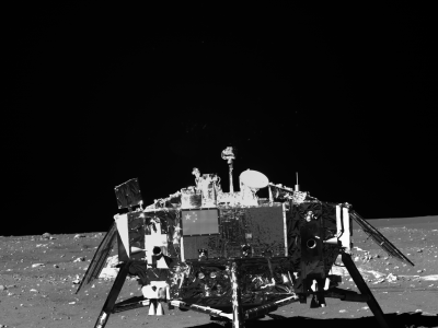
Acquiring imagery of extraterrestrial planetary surfaces has consistently posed a significant challenge. Moreover, the availability of publicly accessible, annotated lunar datasets remains exceedingly sparse. To address this gap in the field, we have developed the Real Chang'e Lunar Landscape Dataset. The images in this dataset were captured by the landing cameras of the Chang'e-3, Chang'e-4, and Chang'e-5 lunar mission probes, as well as the panoramic and terrain cameras carried by the Yutu-1 and Yutu-2 lunar rovers used during the missions.
This dataset contains a total of 7523 lunar surface images, of which 909 images from the Yutu-2 rover have a resolution of 1176×864, while the rest have a resolution of 2352×1728. The images in the dataset come from three different areas of the lunar surface, including both the near side and far side of the Moon, involving various lighting conditions and terrain features. The targets were divided into six categories: probe, sand, gravel, rubble, rock, and crater, with a total of 26710 labels.
Instructions:
If you need original images from the China Lunar and Planetary Data Release System, please visit: https://moon.bao.ac.cn/.
If you need original images from the National Defense Science and Technology Industrial Bureau-supported Key Laboratory Fund, please send an application email to mapleyanbowang@sjtu.edu.cn explaining the purpose of the data. We will provide you with the relevant download links.


