JKU DORA
- Citation Author(s):
-
Pavlo Tkachenko (Johannes Kepler University)Novel Certad Hernandez (Johannes Kepler University)Gunda Singer (Johannes Kepler University)Cristina Olaverri-Monreal (Johannes Kepler University)Luigi del Re (Johannes Kepler University)
- Submitted by:
- Pavlo Tkachenko
- Last updated:
- DOI:
- 10.21227/9w7b-wm55
- Data Format:
 394 views
- Categories:
- Keywords:
Abstract
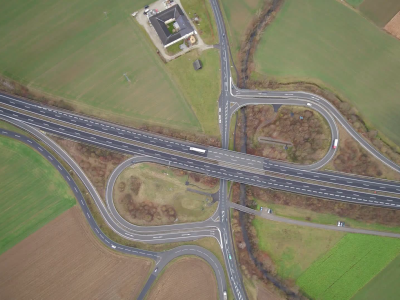
The dataset contains drone measurements of traffic at highway entrances/exits in Austria and Italy. Main features:
- In Austria, the recordings have been made from 300 m height and trajectories of 2521 cars, vans and trucks are extracted over a >600 m long road section
- In Italy, the recordings have been made from 120 m height and trajectories of 2783 cars, vans, buses, motorbikes and trucks are extracted over a >200 m long road section
- Data are provided in local (image-based) and global (road-based) coordinate systems and contatins positions, velocities and accelerations of all moving object
Instructions:
The data are provided in .csv format. Each file contains 17 columns with the following information:
- Frame number (an absolute value starting from 0)
- Time (starts with 0): an absolute time of the recording. In Austria the recordings are taken at 24 frames per second, in Italy – 30 frames per second
- Id (starts with 1): a unique id of each moving object
- x: longitudinal coordinate of a moving object in local (image-based) coordinate system
- y: lateral coordinate of a moving object in local (image-based) coordinate system
- vx: longitudinal velocity of a moving object in local (image-based) coordinate system
- vy: lateral velocity of a moving object in local (image-based) coordinate system
- ax: longitudinal acceleration of a moving object in local (image-based) coordinate system
- ay: lateral acceleration of a moving object in local (image-based) coordinate system
- laneID: a unique id of a lane at which the moving object is located. The most left lane starts with number 1, reference lane 2, acceleration strip 4, feeder lane 14, deceleration strip 3, and exit lane 13. The direction is defined by the laneId's sign
- s: longitudinal coordinate of a moving object in global (road-based) coordinate system
- n: lateral coordinate of a moving object in global (road-based) coordinate system
- vs: longitudinal velocity of a moving object in global (road-based) coordinate system
- vn: lateral velocity of a moving object in global (road-based) coordinate system
- as: longitudinal acceleration of a moving object in global (road-based) coordinate system
- an: lateral acceleration of a moving object in global (road-based) coordinate system
- class: class of a moving object. c – car, v – van, t – truck, b – bus, m – motorbike.