Time Series Satellite data
- Citation Author(s):
-
JAGANNATHAN J
 (Vellore Institute of Technology)
- Submitted by:
- JAGANNATHAN J
- Last updated:
- DOI:
- 10.21227/ev8p-r080
 271 views
- Categories:
- Keywords:
Abstract
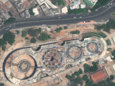
Time-series satellite images provide a sequence of spatial data captured over regular intervals, enabling the analysis of changes on the Earth's surface over time. These images are particularly useful in monitoring environmental phenomena, land use changes, urban development, and agricultural patterns. By examining the same location at different time points, time-series satellite imagery allows for the detection of trends, anomalies, and transitions in land cover. With the integration of advanced machine learning techniques, such as deep learning models, these images can be used for precise classification and prediction tasks, contributing significantly to remote sensing and geospatial research.
Instructions:
Nil